Tim Newbold, Ecology PhD Student - University of Nottingham

Home
Research
About Me
Photographs
Links
Research Overview
Publications
Egypt Expeditions
Talks & Lectures
Species Distribution Modelling
 In order to conserve biodiversity, we must have some idea where itís found. However, many parts of the world, especially in the tropics, have been very poorly surveyed for species. This has led conservation biologists to attempt to predict the distributions of species, using known occurrences of species and maps of climate variables, such as climate, vegetation, habitat and topography.
For the last three years, Francis Gilbert and Samy Zalat have been coordinating BioMAP Egypt, a project that has been collecting sightings of Egyptian species from museum records and from the literature, compiling them into an electronic database. This database now holds over half a million records of species from diverse taxonomic groups.
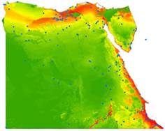
In Nottingham, Francis Gilbert, Tom Reader and I have been using these data to produce predictions of the distributions of Egyptian species. The map shown here is the predicted distribution of the Dorcas Gazelle (Gazella dorcas); warm colours show areas of high predicted probaility, while cooler colours are areas of low predicted probability. We have been testing which variables produce the most accurate predictions and whether certain species are better modelled than others. We have also been making predictions of spatial patterns of species richness, assessing whether Egyptís protected areas provide good coverage of biodiversity.
Recently, we have been collaborating with Stuart Ball of the Joint Nature Conservation Committee and with the British Trust for Ornithology, attempting to predict the impact that climate change will have on the distribution of British hoverfly species.
I have also been collaborating with another PhD student in Nottingham, Rohanna Dow, looking at the importance of interactions between species in determining distributions.